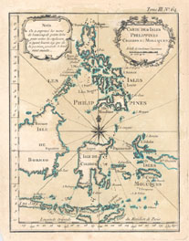
The examples shown here are maps of the Philippines held in the Maps Special Collection. Click on the thumbnail images to see a larger version of the maps. All maps are available for viewing during Special Collections business hours.
Bellin, Jacques Nicolas, 1703-1772. Carte des isle Philippines, Celebes et Moluques. [Paris : Bellin, 1764]. Call Number: G 8060 1764 .B45
From BellinLe Petit Atlas Maritime, 1764
Tome III, No. 64.
Bellin, Jacques Nicolas, 1703-1772. Carte des isles Philippines : dressée sur la carte espagnole du R.P. Murillo de Velarde. [Paris : Bellin,1764] Call number: G 8060 1764 .B44
From BellinLe Petit Atlas Maritime, 1764
Tome III, No. 65-66. The top map (northern portion) is No. 65 and the lower map is No. 66.
Bellin, Jacques Nicolas, 1703-1772. Plan de la baye de Manille située dans l'isle de Luçon. [Paris : Bellin, 1764]
From BellinLe Petit Atlas Maritime, 1764. Call Number: G 8062. M3 P5 1764 .B45
Tome III, No. 67.
Bonne, Rigobert, 1727-1794. Les isles Philippines, celle de Formose, le sud de la Chine, les royaumes de Tunkin, de Cochinchine, de Camboge, de Siam, des Laos, avec partie de ceux de Pegu et d'Ava. [Neuchâtel : Chez les Librairies Associés, 1783?]. Call Number:G 8000 1783 .B65
Note : From G.T.F. Raynal'sAtlas de Toutes les Parties Connues du Globe Terrestre, 1783-1784.
Ptolemy, 2nd cent. [ASIA] [4 Maps]: India Orientalis, Chinae Regnum, Iapania Regnum, Insulae Philippinae [Douay? : Wytfliet?, 1605?] Call Number: G 7401 .S2 1605 .P78
From: Wytfliet's Histoire universelle des Indes..., 1605?
Insulae Philippinae
This map is one of four on one sheet